Spatial Intelligence · Reality Intelligence

Digitising the built world.
Hull to hold. Keel to deck.

ODAM Spatial captures ships, submarines and shipyard facilities in 360°/LiDAR reality capture, then checks the scan against the design model to verify dimensions, thickness and deviations — full-cycle turnaround in under an hour.
PROJECTDigital Built Environment
DWG NOODAM–001
SCALEN.T.S.
REVE
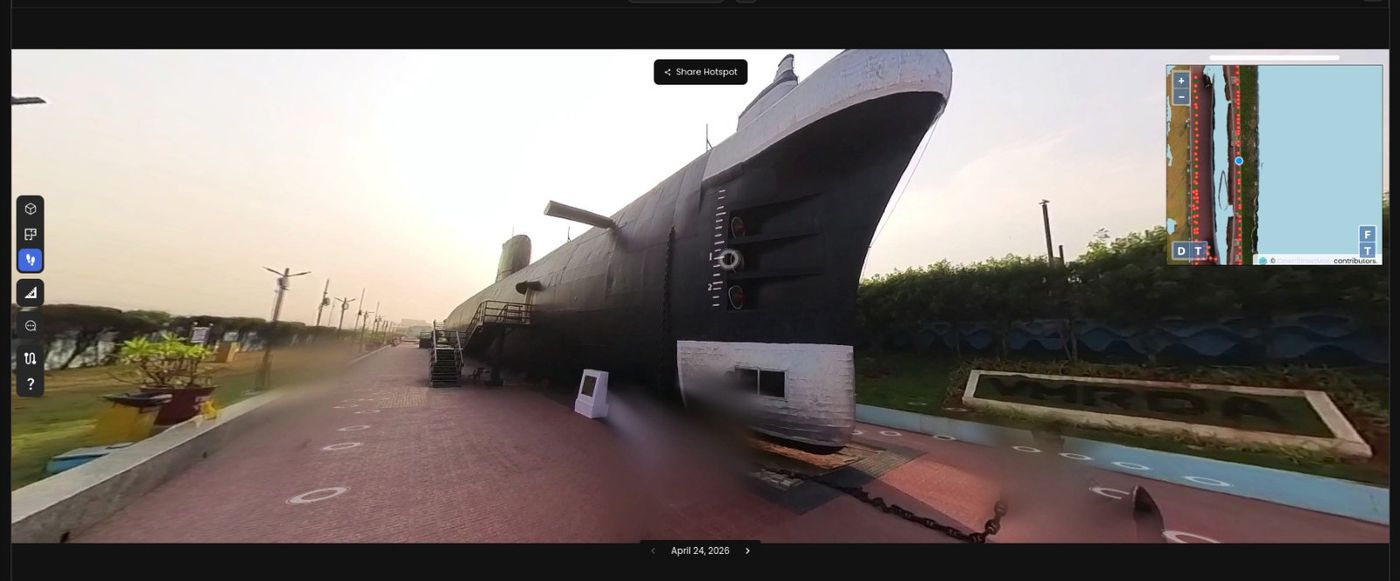
FIG. 01 360-degree reality capture of a submarine hull, Visakhapatnam
LOCATION VISAKHAPATNAM, IN
METHOD 360° + LiDAR
CAPTURED 24.04.2026
Capability Demonstration

The Capture, Direct

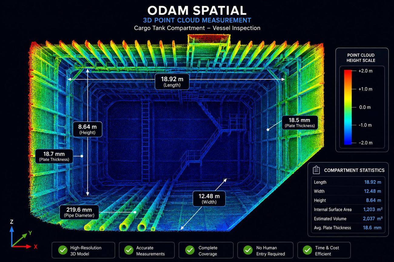
3D point cloud measurement of a cargo tank compartment showing dimensions and plate thickness
FIG. 02 — Cargo tank compartment: 18.92m × 12.48m × 8.64m, 18.6mm avg plate thickness, scan-vs-AVEVA sensor fusion
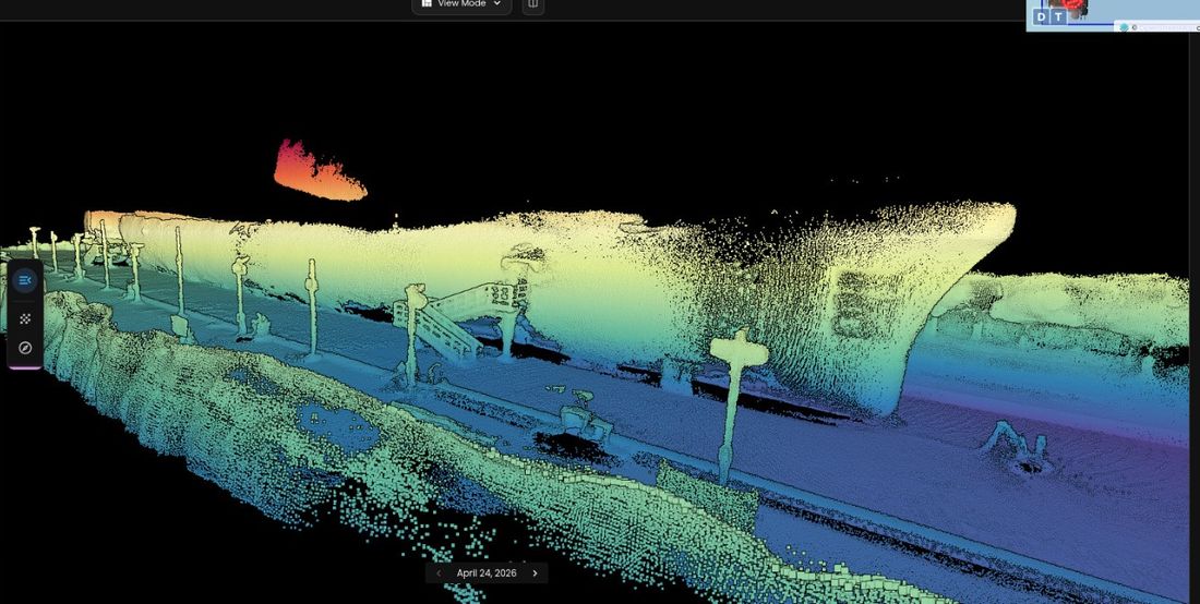
Point cloud of Kursura submarine hull, elevation-mapped
FIG. 03 — Kursura submarine, Visakhapatnam: point cloud, elevation-mapped hull & deck
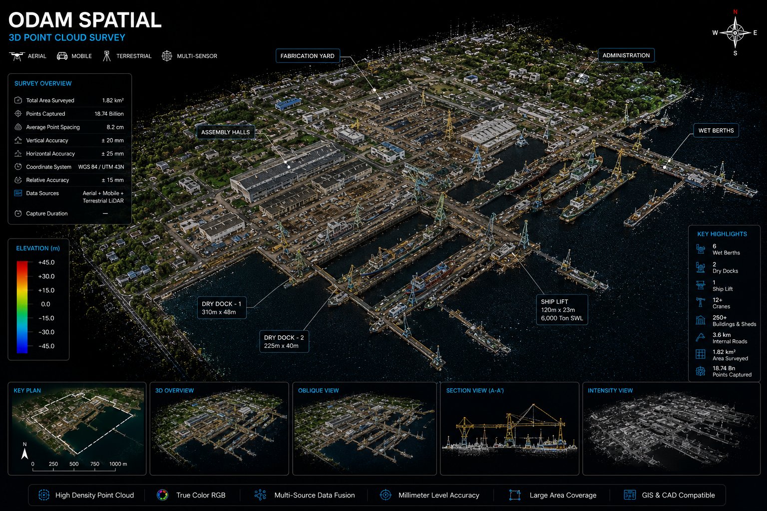
Whole-shipyard 3D point cloud survey showing dry docks, wet berths, cranes, fabrication yard and assembly halls
FIG. 04 — Whole-yard 3D point cloud survey: aerial + mobile + terrestrial LiDAR fusion, millimeter-level accuracy, full facility reconstruction
<1 HR
Full-cycle turnaround
360°+LiDAR
Capture method
On-Prem
Secured deployment
India
Engineered & operated
At A Glance

Capability Index

Twenty-one capabilities across five disciplines. Full detail in the schedule below.

Sheet A
Capture & Metrology
01As-Built Hull & Structure Capture
02Machinery & Compartment Capture
03Dimensional & Thickness Verification
04Tank Volume & Calibration Check
05Large-Scale Yard & Industrial Site Capture
Sheet B
Engineering & Lifecycle
06Scan-vs-Model Comparison
07Retrofit & Upgrade Scanning
08Compartment Redesign Support
09New-Construction Rework Prevention
10As-Built Piping Reconciliation
Sheet C
Operations & Compliance
11Confined-Space, No-Entry Capture
12QA/QC & Repair Monitoring
13Condition & Corrosion Monitoring
14Classification Society Data Support
Sheet D
Digital Twin & Training
15Digital Twin & Remote Review
16Virtual Walkthrough & Training
17Shipyard & Facility Digitisation
Sheet E
Facility-Scale Intelligence
18Whole-Yard 3D Capture & Reconstruction
19Greenfield & Expansion Reference Planning
20Dredging & Shoreline Assessment
21Facility Asset Inventory & Logistics Planning
Why It Matters

What Changes When You Have It

COST
Without it, fabrication proceeds on assumptions.
Clashes and deviations are caught before metal gets cut.
TIME
Without it, survey-to-report cycles stretch into weeks.
Full-cycle scan-to-comparison in under an hour.
SAFETY
Without it, confined-space entry puts people at risk.
Dimensional and condition data captured without tank or void entry.
REWORK
Without it, deviations surface during installation.
Deviations are flagged at the model stage, before fabrication.
PROJECT CONTROL
Without it, oversight relies on periodic walkthroughs.
A granular, navigable record of the asset at any point in time.
COMPLIANCE
Without it, documentation trails are manual and inconsistent.
Structured, auditable capture data that stands up to review.
SECURITY
Without it, sensitive site data leaves the building.
On-prem deployment. Your data stays with you.
HANDOVER
Without it, as-built records are scattered and incomplete.
A structured record for warranty, resale and insurance baseline.
Drawing Index — Full Detail

Schedule Of Capability

The same twenty-one capabilities, in full — organised the way a drawing set is: by discipline.

SHEET A

Capture & Metrology

01
As-Built Hull & Structure Capture
Full hull, decks, superstructure and accommodation spaces captured at true installed condition.
02
Machinery & Compartment Capture
Engine rooms, pipework, HVAC, ballast tanks, cargo holds and void spaces in full spatial detail.
03
Dimensional & Thickness Verification
Scan-vs-AVEVA sensor fusion for measured dimensions, plate thickness, surface area and volume.
04
Tank Volume & Calibration Check
As-captured volume and surface area extraction, cross-checked against calibration and ullage tables.
05
Large-Scale Yard & Industrial Site Capture
Entire shipyards and industrial facilities captured and reconstructed in 3D at scale, processed on-prem — supporting dredging assessment, site-wide layout and infrastructure planning.
SHEET B

Engineering & Lifecycle

06
Scan-vs-Model Comparison
Captured geometry checked against the design model — deviations surfaced automatically, full-cycle under an hour.
07
Retrofit & Upgrade Scanning
Clash detection and pipe-routing verification before cutting into a compartment.
08
Compartment Redesign Support
Redesign against real as-installed geometry, not assumed or outdated drawings.
09
New-Construction Rework Prevention
Stage-gate scan checks catch deviations before outfitting locks a mistake in place.
10
As-Built Piping Reconciliation
Pipe runs and diameters extracted from the point cloud — know what's where before a refit begins.
SHEET C

Operations & Compliance

11
Confined-Space, No-Entry Capture
Dimensional and condition data from tanks and voids without personnel entry.
12
QA/QC & Repair Monitoring
Before/after verification during refits, alignment checks and structural deformation monitoring.
13
Condition & Corrosion Monitoring
Repeat capture builds a time-series record for predictive maintenance planning.
14
Classification Society Data SupportPursuing Class Approval
Bringing scan-verified dimensional and thickness data into the class inspection process.
SHEET D

Digital Twin & Training

15
Digital Twin & Remote Review
A living, navigable reference of the vessel for remote inspection and progress tracking.
16
Virtual Walkthrough & Training
Desktop, VR or AR navigation of the captured asset for training and familiarisation.
17
Shipyard & Facility Digitisation
Dry docks, slipways and workshops mapped for layout and crane-path planning.
SHEET E

Facility-Scale Intelligence

18
Whole-Yard 3D Capture & Reconstruction
Entire shipyards and industrial facilities captured via aerial, mobile and terrestrial LiDAR, fused into a single high-density, survey-grade point cloud.
19
Greenfield & Expansion Reference Planning
Benchmark a new yard's design, or plan an expansion to an existing one, against real as-built geometry instead of assumptions.
20
Dredging & Shoreline Assessment
Berth depth, shoreline and waterway data extracted from the same capture to support dredging volume estimates and environmental filings.
21
Facility Asset Inventory & Logistics Planning
Cranes, berths, docks and buildings catalogued spatially — feeding maintenance systems, asset valuation and crane-path or material-flow simulation.
The Pipeline

Capture. Compare. Deliver. Control.

01

Capture

360° and LiDAR reality capture of the physical asset.

02

Compare

Captured geometry checked against the design model.

03

Deliver

Full-cycle turnaround, under an hour, to a reviewable report.

04

Control

Navigate the asset and maintain oversight without being on site.

Continued Evidence

Kursura Submarine, In Full

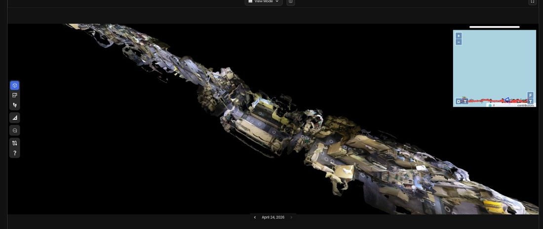
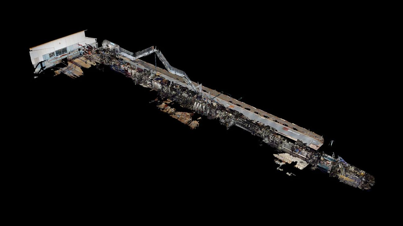
The same capture, processed further — textured reconstruction and full-vessel model, using the same pipeline run on commercial and industrial projects.
Textured mesh reconstruction of submarine compartment
FIG. 05 — Textured reconstruction, structural detail
Full vessel reconstruction
FIG. 06 — Full vessel, capture-to-model
Beyond The Scan

Walk It. Don't Just View It.

Captured data becomes an interactive walkthrough — navigate compartments, inspect systems, and review the asset remotely, without physical access.

  • Remote, repeatable access to the asset
  • Deployable on desktop, VR, or AR
  • Built for training, familiarisation, and stakeholder review
  • No dependency on physical availability of the asset
Interactive virtual tour of captured vessel
Sovereign. Secure.

Made Here. Stays Here.

ODAM Spatial is engineered and operated end-to-end in India. Every deployment can run fully on-premise — your data never leaves your site.

For strategic and classified projects, that isn't a feature. It's the requirement that makes the project possible at all.

DeploymentON-PREMISE / CLOUD-OPTIONAL
Data residencyCLIENT SITE, INDIA
EnginePROPRIETARY, INDIGENOUS
OperationsEND-TO-END INDIAN
Not Off The Shelf

Engineered To Order

Every deployment is scoped to the asset, the site, and the constraints you actually have. Turnkey where you want turnkey. Integrated into your existing workflow where you don't.

Capture360° / PHOTOGRAMMETRY / LiDAR
ComparisonSCAN-VS-MODEL, AVEVA & CAD
DeliveryTURNKEY OR INTEGRATED
ScaleSINGLE ASSET TO FACILITY-WIDE
Let's Talk

Schedule A Capability Demo

See the capture-to-comparison pipeline on a real asset, and talk through what an engagement would look like for your site.

Email Us →
Office
198, 2nd Floor, CMH Road,
Indiranagar, Bengaluru 560038
Company
ODAM Spatial Private Limited